334,99 €
inkl. MwSt.
Versandkostenfrei*
Versandfertig in über 4 Wochen
payback
167 °P sammeln
  • Gebundenes Buch

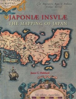
The Mapping of Japan systematically categorizes and provides an overview of all the European printed maps of Japan published to 1800. The author has undertaken a review of the literature, conducted an exhaustive investigation in major libraries and private collections, analyzed these findings and then compiled information on 125 maps of Japan. The introduction contains information about the mapping to 1800, the typology of Japan by western cartographers, an overview on geographical names on early modern western maps of Japan and a presentation of the major cartographic models developed for…mehr

Produktbeschreibung
The Mapping of Japan systematically categorizes and provides an overview of all the European printed maps of Japan published to 1800. The author has undertaken a review of the literature, conducted an exhaustive investigation in major libraries and private collections, analyzed these findings and then compiled information on 125 maps of Japan. The introduction contains information about the mapping to 1800, the typology of Japan by western cartographers, an overview on geographical names on early modern western maps of Japan and a presentation of the major cartographic models developed for this book. This is Volume XIV of the Utrecht Studies on the History of Cartography (Explokart). This series is prepared under the direction of the Research Program URU-Explokart of the University Utrecht. It is aimed at both researchers and laymen with an interest in these matters.
Autorenporträt
Jason Hubbard (1944) has collected maps for several decades, about which he has published in Imago Mundi, and has written a number of articles for both the printed as well as the web version of Map Forum. He is a Fellow of the Royal Geographical Society, member of The Club of Odd Volumes in Boston, MA and of the International Map Collector's Society. The author was raised and educated in Mexico City and graduated from the University of the Americas with a Master's in Business Administration. He spent 25 years with Polaroid Corporation in a variety of marketing and management assignments in Latin America, the Far East, Europe and North America. His travels, both for business and for pleasure have taken him to well over 100 countries. His passion for maps dates from 1971 when he made his first purchase, a map by Blaeu, whilst residing in Panama.