Discovering London Illustrated Map
-
- Englisch ausgewählt
6,49 €
inkl. gesetzl. MwSt.,
Lieferung nach Hause
Beschreibung
Produktdetails
Verkaufsrang
5373
Einband
Karte
Erscheinungsdatum
27.03.2025
Verlag
Collins LearningMaße (L/B/H)
20,3/10,3/2,7 cm
Gewicht
70 g
Sprache
Englisch
ISBN
978-0-00-872465-8
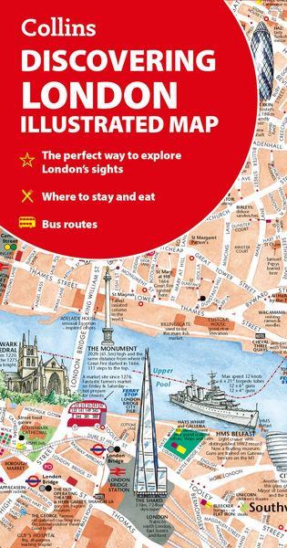
A new edition of London's most original map. This hand-watercoloured map contains individual paintings of all the main sites and landmarks, shop-by-shop street maps, theatres and cinemas, comprehensive travel information and index. This detailed map of Central London is at a scale of 1:8,250 (7.5 inches to 1 mile).
Coverage extends from Regent's Park in the north to Battersea in the south, and from Kensington in the west to Tower Bridge in the east.
This attractive and fact-filled map would make a lovely souvenir for the visitor to London.
The map features:
- Railway stations, bus routes, London underground map, taxi ranks and car parks
- Shop-by-shop street maps for Oxford Street, Bond Street, Covent Garden, Portobello Road, King's Road, Brompton Cross, Exmouth Market, Beauchamp Place, St. Christopher's Place and South Molton Street, Knightsbridge, Jermyn Street and Kensington
- London's theatres and cinemas
- Places to eat, internet cafés and good places for a picnic
- An inset map of the City of London
- Comprehensive index
- Historical and contemporary anecdotes
Other titles in the series:
- Discovering Edinburgh
- Discovering Glasgow
Kundinnen und Kunden meinen
Verfassen Sie die erste Bewertung zu diesem Artikel
Helfen Sie anderen Kund*innen durch Ihre Meinung
Kurze Frage zu unserer Seite
Vielen Dank für dein Feedback
Wir nutzen dein Feedback, um unsere Produktseiten zu verbessern. Bitte habe Verständnis, dass wir dir keine Rückmeldung geben können. Falls du Kontakt mit uns aufnehmen möchtest, kannst du dich aber gerne an unseren Kund*innenservice wenden.
zum Kundenservice