Satellite Radar Interferometry Subsidence Monitoring Techniques
-
- Hardcover
- Taschenbuch ausgewählt
-
Sprache:Englisch
139,99 €
UVP
160,49 €
inkl. gesetzl. MwSt.,
Lieferung nach Hause
Beschreibung
Produktdetails
Einband
Taschenbuch
Erscheinungsdatum
28.10.2010
Abbildungen
XVI, 139 illus., 46 illus. in color., schwarz-weiss Illustrationen, farbige Illustrationen
Verlag
Springer NetherlandSeitenzahl
244
Maße (L/B/H)
23,5/15,5/1,7 cm
Gewicht
447 g
Auflage
1. Auflage
Sprache
Englisch
ISBN
978-90-481-8125-4
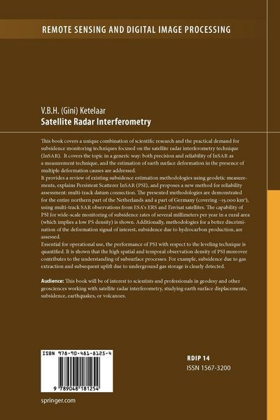
This book covers a unique combination of scientific research and the practical demand for subsidence monitoring techniques focused on the satellite radar interferometry technique (InSAR). It covers the topic in a generic way: both precision and reliability of InSAR as a measurement technique, and the estimation of earth surface deformation in the presence of multiple deformation causes are addressed.
It provides a review of existing subsidence estimation methodologies using geodetic measurements, explains Persistent Scatterer InSAR (PSI), and proposes a new method for reliability assessment: multi-track datum connection. The presented methodologies are demonstrated for the entire northern part of the Netherlands and a part of Germany (covering ~15.000 km 2 ), using multi-track SAR observations from ESA’s ERS and Envisat satellites.
The capability of PSI for wide-scale monitoring of subsidence rates of several millimeters per year in a rural area (which implies a low PS density) is shown. Additionally, methodologies for a better discrimination of the deformation signal of interest, subsidence due to hydrocarbon production, are assessed.
Essential for operational use, the performance of PSI with respect to the leveling technique is quantified. It is shown that the high spatial and temporal observation density of PSI moreover contributes to the understanding of subsurface processes. For example, subsidence due to gas extraction and subsequent uplift due to underground gas storage is clearly detected.
Audience:
This book will be of interest to scientists and professionals in geodesy and geophysics working with Radar Interferometry, studying displacements, subsidence, earthquakes, or volcanoes.
Kundinnen und Kunden meinen
Verfassen Sie die erste Bewertung zu diesem Artikel
Helfen Sie anderen Kund*innen durch Ihre Meinung
Kurze Frage zu unserer Seite
Vielen Dank für dein Feedback
Wir nutzen dein Feedback, um unsere Produktseiten zu verbessern. Bitte habe Verständnis, dass wir dir keine Rückmeldung geben können. Falls du Kontakt mit uns aufnehmen möchtest, kannst du dich aber gerne an unseren Kund*innenservice wenden.
zum Kundenservice